Home | About Me | Jewelry Designs | Gemstones | Mineral Specimens | Mine Info | Orders | FAQs | Contact | Links |
||
 |
||||
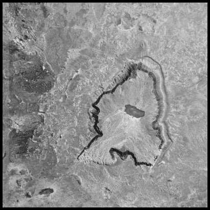
Aerial Photograph of Kilbourne Hole, Dona Ana County, New Mexico |
||||
Shown here is an aerial photograph of Kilbourne Hole. The dark area in the center of the crater is an intermittent lake. Erosion along the southern border (bottom of image) of the crater has washed away the bounding rim that is still prominent along the eastern and western sides. Sediment has washed into the crater bottom and burried any volcanic "bombs" that might have fallen back into the crater after the eruption. Prime olivine collection areas are the volcanic breccias that rise above the crater edges. |
|||||
 |
|||||
If you would like to see a 3D topographic tour of Kilbourne Hole, you might wish to view this web page. The tour requires that you have the Google Earth Plugin installed on your computer, and that you have a fast web connection. |
|||||